 The
Science Notebook
Gilbert Weather Bureau - Part
II
The
Science Notebook
Gilbert Weather Bureau - Part
II
NOTE: This book was published around 1920 as a
manual to accompany the Gilbert Weather Bureau sets.
The sets and manual were part of the "Boy Engineering"
series, While some of the experiments and activities here
may be safely done as written, some of them may be considered
hazardous in today's world, such as handling a mercury
barometer. In addition, some of the information
contained in this book is either outdated
or inaccurate. Therefore, this book is probably
best appreciated for its historical value rather than as a
source for current information and good experiments. If
you try anything here, please understand that you do
so at your own risk. See our Terms of
Use.
Pages 22 - 43
22 GILBERT BOY ENGINEERING
NOTE: Many figures have been
relocated from their position in the printed text to make them
more readable on a web page. This may or may not be
indicated in the text.
Volcanic Winds:
Due to volcanic eruption, which produces an outrush of air.
A Squall:
Due to the sudden disturbance in temperature.
A Simoon:
A desert wind.
VELOCITY
OF WIND
The wind blows a great deal hoarder on water than on land, because
on land it meets with various obstacles, whereas it has very little
friction on the water.
THE
FORCE OF THE WINDS
Wind blowing at 20 miles per hour has a force of 1 1/4
lbs.
Wind blowing at 35 miles per hour has a force of 6
lbs.
Wind blowing at 50 miles per hour has a force of 13 lbs.
Wind blowing at 75 miles per hour has a force of 28
lbs.
Wind blowing at 90 miles per hour has a force of 40 lbs. |
GILBERT
WEATHER BUREAU 23
[Originally contained Figs. 18-23]
24 GILBERT BOY ENGINEERING
[Originally contained Figs. 19A-23A]
GILBERT WEATHER BUREAU 25
NAME
OF WINDS
Beaufort's scale, used in preparation of all Weather Bureau wind
forecasts and storm warnings.
FORCE
0
1
2
3
4
5
6
7
8
9
10
11
12 |
DESIGNATION
Calm
Light Air
Light breeze (or wind)
Gentle breeze (or wind)
Moderate breeze (or wind)
Fresh breeze (or wind)
Strong breeze (or wind)
Moderate gale
Fresh gale
Strong gale
Whole gale
Storm
Hurricane |
MILES PER HOUR
From 0 to 3
Over 3 to 8
" 8 " 13
" 13 " 18
" 18 " 23
" 23 " 28
" 28 " 34
" 34 " 40
" 40 " 48
" 48 " 56
" 56 " 65
" 65 " 75
" 75 |
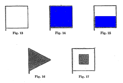
The following method of transmitting weather signals by means of
flags was used for a number of years, but the newspapers now convey
the same news to the interested public:
 [Color added]
2. A square blue flag indicates rain or
snow. (See Fig. 14.)
3. A white and blue flag, half white and half blue, indicates
local rain or snow. (See Fig. 15.)
4. Black triangular flag indicates a change in
temperature. (See Fig. 16.)
5. White flag with a square black center indicates cold
wave. (See Fig. 17.)
When No. 4 is placed above No. 1, 2, or 3, it indicates warmer
weather; when below, colder; when not displayed the temperature is
expected to remain stationery.
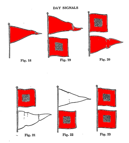
The following flag warnings are used along the Atlantic and gulf
coasts to notify inhabitants of this section of the country of
impending danger.
 [Color added]
 [Color added]
Fig. 19. The
Northeast Storm Warning. A red pennant above
26
GILBERT BOY ENGINEERING
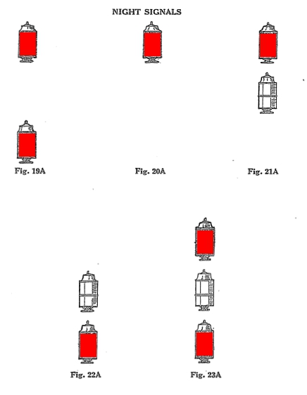
a square red flag with black center displayed by day, or two red
lanterns, one above the other, displayed by night (Fig. 19A),
indicates the approach of a storm of marked violence, with winds
beginning from the northeast.
Fig. 20. The Southeast Storm
Warning. A red pennant below a square red flag with
black center displayed by day, or one red lantern displayed by night
(Fig. 20A), indicates the approach of a storm of marked violence
with winds beginning from the southeast.
Fig. 21. The Southwest Storm
Warning. A white pennant below a square red flag with
black center displayed by day, or white lantern below a red lantern
displayed by night (Fig. 21A), indicates the approach of a storm of
marked violence, with winds beginning from the southwest.
Fig. 22. The Northwest Storm
Warning. A white pennant
GILBERT
WEATHER BUREAU 27
above a square red flag with black center displayed by day, or a
white lantern above a red lantern displayed by night (Fig. 22A),
indicates the approach of a storm of marked violence, with winds
beginning from the northwest.
Fig. 23. Hurricane, or Whole
Gale Warning. Two square flags, red with black
centers, one above the other, displayed by day, or two red lanterns,
with a white lantern between, displayed by night (Fig. 23A),
indicates the approach of a tropical hurricane, or one of the
extremely severe and dangerous storms which occasionally move across
the Great Lakes and Atlantic Coast.
We have installed at our manufacturing plant a high-class weather
station, with equipment of the latest United States Weather Bureau
standard pattern, and are able to send out weather signals by
wireless from our own wireless station twice daily, at 4 P.M. and 7
P.M., to all boys owning a wireless outfit. The indications
are taken from our own instruments. A description of these
instru-
28
GILBERT BOY ENGINEERING
ments and the method of recording the indications will give you an
insight into how the various government weather stations arrive at
their forecasts.
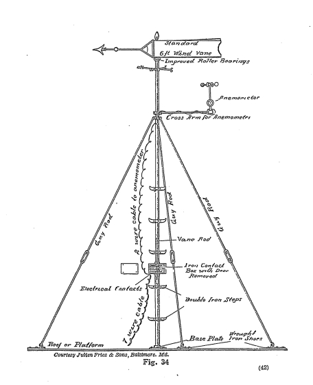
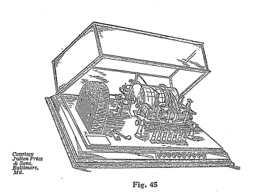
On the roof of the factory is a weather vane (Fig. 34) twenty feet
high, which is connected electrically with a register in our weather
office. The register is of the quadruple type (Fig. 45), and
is capable of recording wind direction, wind velocity, rainfall, and
sunshine on the same form or sheet. Thus we know the wind
direction and can deduce certain things relating to the
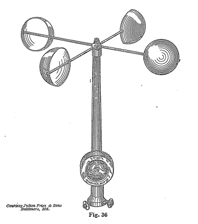
weather. Mounted on the wind vane support is an anemometer
(Fig. 36), an instrument for measuring the velocity of the
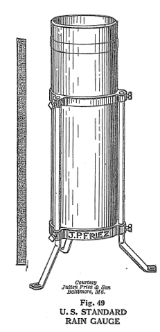
wind. Our rain gauge (Fig. 49) on the roof catches the
precipitation, and for every one hundredth of an inch of rainfall, a
small tipping bucket empties its contents into a receiver and a
record is made on the form in the quadruple register.
The same pan that records the rainfall also records the number
GILBERT
WEATHER BUREAU 29
of hours of sunshine a day, for it is not a common thing to have
rain and sunshine at the same time.
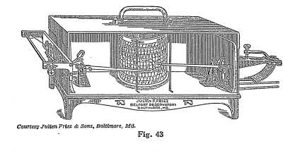
A hygrothermograph (Fig. 43) records on a form the temperature and
amount of humidity in the atmosphere.
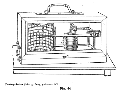
A barograph (Fig. 44) records the pressure of the atmosphere.
For determining the pressure, we also have a mercurial and aneroid
barometer, which will be described later on.
You can readily see that it is a simple matter to obtain the weather
indications.
CLOUDS
The numberless kinds of clouds makes it quite difficult to describe
and arrange them or illustrate them in any manner that makes it easy
to recognize them. Although some may be recognized from
description and with a fair amount of observation, you will be able
to classify them in their proper place. For instance,
30
GILBERT BOY ENGINEERING
the thunder clouds most anyone recognizes without any experience
whatever.
There are really four simple cloud formations and three compound
formations:
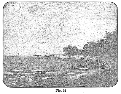
1. The Cirrus Cloud.
(Fig. 24.)
The Cirrus cloud is always seen high in the sky, and data great
elevation. Its formation is fibrous and it is particularly
characterized for its many varieties of shapes. It also has of
marked delicacy of substance and it is pure white.
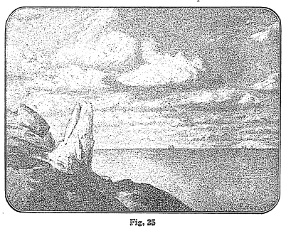
2. The Cumulus Cloud.
(Fig. 25.)
The Cumulus cloud is of moderately low elevation. It is a
typical cloud of a summer day. It may be recognized by little
heaps or bushes rising from a horizontal base. In
summer-time we are all familiar with the cumulus clouds rising with
the currents of air in huge masses. They form one of the most
accurate indications of
GILBERT
WEATHER BUREAU 31
fair weather when you see them gradually dissolving. Sometimes
these clouds become very large, and while the texture is generally
of a woolly white, naturally, when they assume such large sizes com
they gradually change in color to a darkish tint.
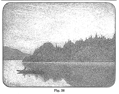
3. The Stratus Cloud.
(Fig. 26.)
This is the opposite of the Cirrus cloud, because it hangs the
lowest of all, in gray masses or sheets, with a poorly-defined
outline.
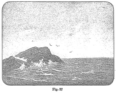
4. The Nimbus Cloud.
(Fig. 27.)
Any cloud can be classed as a nimbus cloud from which rain or snow
is falling.
Of the compound clouds we have:
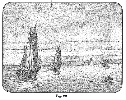
1. The Cirro-Cumulus Cloud
(Fig. 28), which has all the characteristics of both the Cirrus and
the Cumulus. The most characteristic form of this cloud, and
the one most commonly known, is when these clouds form small round
masses, which appear to be
32
GILBERT BOY ENGINEERING
cirrus bands broken up and curled up. This is what people
called the "mackeral" sky.
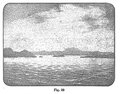
2. The Cirro-Stratus Cloud (Fig. 29), which is known when
the clouds arrange themselves in thin horizontal layers at a great
elevation.
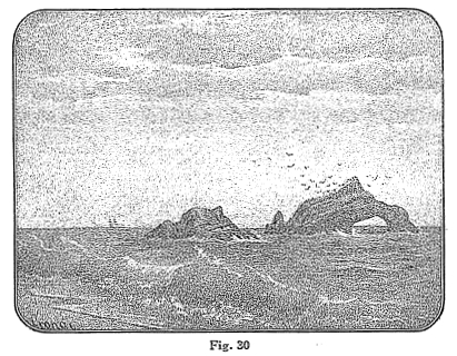
3. The Cumulo-Stratus
(Fig. 30) is the cumulus and the stratus blended together.
Their most remarkable form is in connection with approaching thunder
storms, and are often called thunder heads. They rapidly
change their outline and present a beautiful spectacle in the sky at
times.
The Cirrus, Cirro-Cumulus, and Cirro-Stratus are known as the upper
clouds and the others are known as the lower.
ATMOSPHERIC
DISTURBANCES
Disturbances of the atmosphere are classified as follows: Cyclonic,
or low area storms, or anticyclonic, or high area storms.
GILBERT
WEATHER BUREAU 33
The word "cyclone" to most people immediately means a terrific
storm, whereas in weather observing the cyclonic storm is not really
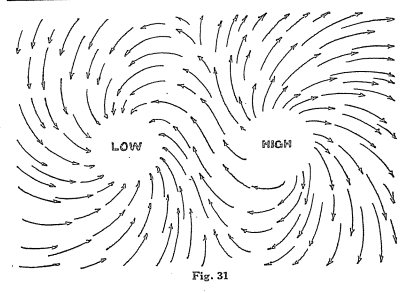
a cyclone or hurricane at all. It is a storm with an
atmospheric pressure below average. Particularly important is
the wind that blows about this area, which is always a spirally
inward, due to the rotation of the earth on its axis. This is
probably why it is given the name of cyclonic storm, for it bears
one of the important characteristics of a real cyclone. As the
wind is deflected and moves into the storm's center, it turns to the
right in the form of a whirlwind, spirally, moves around the storm's
center. (See Fig. 31.) It is this whirling process that
has given it the named, cyclonic storm.
As the air rises over the point of low storm area, or, in other
words, the area of low pressure, and travels into the atmosphere, it
is not permitted to rise to any great height, because it is always
acted upon by the force of gravity and is being pulled back to earth
again. We assume that because of this fact, this rising air
which has been pulled back to the earth again piles up in certain
places,
34
GILBERT BOY ENGINEERING
causing the barometer to rise. Such a center as this is known
as a high barometric center or the anti-cyclonic area. Here
the circulation of the air is exactly opposite to that of the
cyclonic area.
We are all more or less acquainted with these anti-cyclonic storms,
because in winter these great masses of air rise up from the warm
areas, pile up, and form high pressure areas over the mountains of
Canada, and soon this high pressure works down upon us as blizzards
and cold waves.
We have described quite minutely the movements of the wind about
these points of high pressure and low pressure and have shown you
the map and have illustrated the high pressure and low pressure
areas, but there is still another feature that is of great
importance to us, and that is the movement of the storms and the
fact that storms have a progressive movement from west to
east.
These storms move more rapidly in the United States than elsewhere,
and are more rapid in their movement in winter than in summer.
Their speed is almost one half again as great. The average
velocity of the low area storm in the United States is about
twenty-five miles an hour in June, July, August, and September, and
from October on they continue to increase.
GILBERT
WEATHER BUREAU 35
LOW
PRESSURE
We can summarize low-pressure storms generally in the following
manner: they have a wind circulation inward and upward and are
elliptical in form. Their velocity varies from six hundred to
nine hundred miles per day, moving in the same general
direction. They are characterized in their eastern quadrants
by cloudy weather, southerly and easterly winds,
precipitation, temperature oppressive in summer and abnormally high
in winter, falling barometer, increasing humidity and falling
temperature followed by clear weather, rising barometer, decreasing
humidity and falling temperature in the western quadrants.
Buys Ballots' law of winds is, that in the Northern Hemisphere if
one stands with his back to the wind, the low barometric pressure
will be invariably to the left hand; in the Southern Hemisphere the
lowest pressure is always to the right. This law explains one
of the characteristics of low-pressure storms.
AREAS
OF HIGH PRESSURE
In speaking of low-pressure storms we call them storms centers,
because nearly always they are of sufficient intensity to bear that
name, but in high pressure areas we do not speak of them as storms
centers.
The Buys Ballots' law Applies to anti-cyclonic as well as cyclonic
storms, that is, when one's back is to the wind, the lowest
barometric pressure is at the left and the highest is at the
right. This is probably understood by saying that in the
cyclonic storms, the winds blow inward, contrary to the hands of a
watch, and in the anti-cyclonic they blow outward, that is, in the
same direction to the direction of the hands of the watch.
In the United States, the cyclonic storms are not as frequent as
low-pressure storms, and it is safe to say that probably not more
than one-third of the entire anti-cyclonic areas can be classed as
storm areas.
WHY
AIR RISES
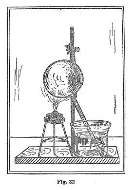
Another very interesting experiment is to secure a long-stemmed
glass bulb (see Fig. 32). Arrange this apparatus as
illustrated, with the stem of the bulb immersed in the water.
The glass bulb condenses the air. When you first put it into
the water nothing
36
GILBERT BOY ENGINEERING
happens, but as soon as you apply the heat the air bubbles come out
of the end of the tube. This means that the air in the tube
has expanded and part of it has come out through the stem of the
tube and the remainder is lighter. It is well to remember,
when air is heated it expands and becomes lighter. This fact
is extremely important to remember, because it has a great deal to
do with the important instrument, the barometer, which is used to
measure the pressure of the atmosphere and is an important element
in the question of humidity, as you will learn later. By this
time you have no doubt learned that:
1. Air has weight.
2. Heated air expands, becomes lighter, and exerts less
pressure.
3. Cold air comes from the side to take the place of hot air
that rises.
When the rays of the sun heat an area of the earth, the air over
such a place expands and becomes lighter, naturally rising, and the
result of this is that the winds are produced by cool air moving in
to take the place of the heated air. This cool air moves in
from all directions. When such a thing happens at any point on
the earth's surface, it is known as a storm center, an area of low
pressure.
WHAT
IS A CYCLONIC STORM?
Because of the rotation of the earth on its axis, a force arises
which tends to deflect to the right all motions in the northern
hemisphere, and to the left all motions in the southern
hemisphere. The winds flowing toward the storm center are
turned to the right or left and move in a spiral around the storm
center. This system of whirling winds around a central region
of low pressure produce what is termed a cyclonic storm.
Storms have a tendency to move in an easterly or northeasterly
direction, and at a rate of from five hundred to seven hundred miles
a day. Cyclonic storms, although we look at them as being very
severe, are very often mild and not of an intensive character.
WHICH
WAY DOES THE WIND BLOW AFTER A STORM?
From the descriptions and experiments preceding, which illustrate
the development of storms, reference was made only to the winds
blowing in toward the storm center. Naturally the question
GILBERT
WEATHER BUREAU 37
comes to your mind: What happens to them after the cold air
has taken the place of the warm air? They change to other
directions when the storm has passed away. It is because of
this fact that we look for a change in weather conditions when the
wind changes - a very important sign that you will be interested in
later on.
It is well to mention here a thing that is going to be very
important to us when we study the barometer, that is, the pressure
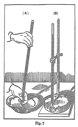
of the atmosphere. Should the pressure of the air, which is
normally at sea level 14.7 pounds to the square inch, change, that
is, become lighter, it would not exert so much pressure on the
column of mercury in the tube of the barometer and the mercury would
drop in the tube. (See Fig. 7.) On the other hand, if
the weight of the air was increased, that is, if it became heavier,
it would force the mercury to rise in the tube. This should be
quite clear to you, because it iis the lightness and heaviness of
the air that is going to interest us more particularly than any
other part of the subject when we get into the study of the
atmospheric changes, what causes them, and the indications that lead
up to our conclusions. In order that this principle is
absolutely clear to you, you should perform Experiment 4, or if you
have not the facilities for doing it, it is well to see it performed
in any physics laboratory.
Immediately ask yourself: If air has such a tremendous
pressure as 14.7 pounds to the square inch, why is it that a weight
of air amounting to thirty-five thousand pounds bearing down on the
average individual does not cave the body in? Simply because
air penetrates the body so easily that it exerts as much pressure on
the inside as on the outside, and thereby equalizes itself.
For instance, if you go down into a subway or a caisson (a
water-tight box or chamber within which submarine construction is
carried on under great air pressure to keep out the water), where
the pressure is sometimes greater than it is outside, have you
noticed the effects this pressure exerts on the ear drums? As
it becomes greater, you may equalize it by swallowing, which allows
the air to get back of the ear drums through the Eustachian tubes,
which lead from the mouth to the inner ear.
MOISTURE
Water vapor is always present in the air.
38
GILBERT BOY ENGINEERING
EXPERIMENT
NO. 10
Expose a piece of dry potash to the air. You will soon
discover that the potash will dissolve. It has taken up water
from the air.
EXPERIMENT
NO. 11
Put a piece of ice in a pitcher of water and allow it to stand in a
warm room. You will soon notice that little beads of
perspiration collect on the outside of the pitcher. This
moisture is air being condensed.
Water vapor is part of the atmosphere. Some of it is always
present in the air. The amount of water vapor that the air can
hold depends upon the temperature. When the temperature is
warm, the air will hold more water. For instance, at 100° F. a
cubic foot of air will hold 19.78 grains of vapor; at 80° F., 10.95
grains; at 50° F., 4.09 grains, and at 32° F., 2.17 grains. At
32° F. is the freezing point on the Fahrenheit scale.
Air containing as much water vapor as it can hold is
saturated. If the air is suddenly cooled down, that is, if the
temperature falls when the air is saturated, air molecules are
contracted, and it must give up the water, which produces
rain. The ocean and the Great Lakes are the source from which
the air gets its water. It rises into the air in the form of
vapor, that is, vapor rising from the surface of the water, and the
wind distributes it over the land. Condensation turns it into
clouds, and when it is over-saturated, or rather, when the
temperature drops and the air is unable to retain any more water,
then it forms into drops of water and falls as rain. When the
clouds get into the air, below the freezing point of the water, the
drops of water are changed into ice crystals or snowflakes.
When the ice crystals are just to the point of melting into water,
due to the rise in temperature, the snowflakes lose their form and
the result is sleet.
HOW
CAN WE USE THESE FACTS?
So far we have described, in a general way, certain facts about the
elements of the air, such as temperature, pressure, humidity,
precipitation, evaporation, clouds, winds, etc., and these facts of
the elements enter into a very interesting phase of weather
obser-
GILBERT WEATHER BUREAU 39
vation which we will designate as prophesying without instruments or
forecasting by physical science. When we come to the more
interesting and scientific part of weather observation, we will drop
the word "prophecy," because the instruments that are used to
measure these elements are going to indicate certain things to us
that will lead you to more definite conclusions. Hence, the
following observations are what have given an opportunity to the
weather prophet or to those people who have been credited with some
mysterious power to prophesy what the weather is going to be.
They are not definite or conclusive, and they cannot always be
depended upon, but they certainly are significant and interesting,
and a description of weather would not be complete without a list in
chronological order of a series of phenomena or physical signs of
this character that have led certain men to gain quite a reputation
for prophesying what the weather is going to be.
APPEARANCES
Various appearances that come from the sky.
For instance, a good example is in the case of the thunder storm,
40
GILBERT BOY ENGINEERING
which can be determined at least a few hours in advance, by the
movement of the clouds and the forms they take. In every
locality there is a direction that clouds take that forecasts bad
weather, and there is a direction that clouds take that forecasts
fair weather.
When you see a halo about the top of a mountain, you know that bad
weather is expected. The same is true when a halo appears
about the moon. This indicates rain, or if the lower clouds
break up and the upper clouds, or a second light covering of clouds,
are seen above the lower ones, it speaks for continued bad
weather. In some localities if rainy weather is continuing or
some time, and a certain change in wind sets in, it will indicate
that good weather is coming.
These observations will be readily understood as being adapted for
certain localities and are not general. It is always necessary
that the observer adapt himself to these localities and study them,
so that he can make prophecies accordingly. It should be borne
in mind that these prophecies are only possible from one day to
another.
WHAT
THE CLOUDS INDICATE
When high clouds are seen crossing the sun or the moon in a
different direction from the lower clouds, this indicates a change
of wind toward the direction of the higher clouds. When you
see hard-edged clouds, look for wind. When you see delicate
soft clouds, look for fine weather and probably moderate breeze or
high breeze. When you see gloomy dark clouds in a blue sky,
look for slight winds. When you see a bright blue sky through
fine clouds that are soft and delicate, this indicates fine
weather. When you see soft-looking clouds, you can expect less
wind, but probably rain. But when the clouds become hard and
ragged, tufted and rolling in appearance, stronger winds are
coming. When you see small clouds that are inky looking, look
for rain. When you see like clouds traveling across heavy hard
masses of clouds, this indicates both wind and rain, but if the
light scud clouds are alone, you may expect wind only. Misty
clouds forming or hanging over the peaks of hills indicate both wind
and rain. If during a rainy spell they ascend or disperse the
weather is pretty certain to clear up. If there has been fine
weather and you begin to see light
GILBERT
WEATHER BUREAU 41
streaks in the sky which are distant clouds, and they continue to
increase and grows into cloudiness, this indicates rain.
SUNSET
AS AN INDICATION
When the sun is setting and the sky in the west presents a color of
whitish yellow or radiates out at a great height, rain can be looked
for during the next night or day. Gaudy colors where clouds
are definitely outlined indicate probably wind and rain.
Before setting, if the sun looks diffused and the color is a
brilliant white, this forecasts storms. When the sun sets in a
slightly purple sky and the color at the zenith is a bright blue,
this indicates fine weather. A red sunset generally indicates
good weather, whereas a ruddy or misty sunset indicates bad
weather.
WHAT
THE SKY INDICATES
When you see a dark, dismal sky, look for rain. A sky with a
greenish hue, described as a sickly-looking sky is an indication of
both rain and wind. A sailor's sky, which is red in the
morning, means either wind or rain, and it makes no difference if
the sky is cloudy or clear, if at sunset it is rosy, it indicates
fine weather. A gray sky in the morning indicates fine
weather. When daylight is first seen above a bank of clouds,
look for a good stiff wind. Wind is indicated if we have a
bright yellow sky in the morning, and rain is indicated if the sky
takes on a pale yellow hue. If the sky turns bright yellow
late in the afternoon, it generally indicates that rain is near at
hand. Unusual colorations, particularly of deep intense color,
indicate wind or rain.
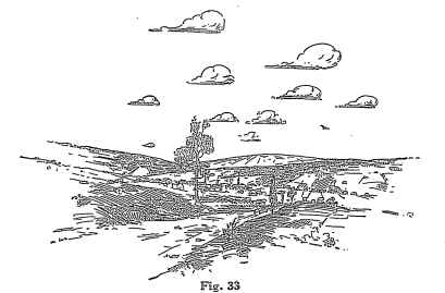
The the following appearances indicate a change in the weather: when
the atmosphere is clear and crystalline and the stars appear
extremely bright; when the background of the horizon seems to be
pinned up against the foreground; when the clouds form into delicate
white film-like mist way up overhead. (Fig. 33.)
WHAT
FOG AND DEW INDICATE
Locality has considerable to do with what the fog indicates.
As a rule, where you have fog there is not much wind, and as a
result it does not indicate stormy weather, unless the fog becomes
heavy with overhanging sky, then it is set to turn into rain, but a
(42)
GILBERT
WEATHER BUREAU 43
heavy fog with a light sky indicates fine weather. A fog in
the morning generally indicates a fair day. A rising fog is a
good indication for fair weather.
Dew is a pretty good sign of fine weather. When you can see
and hear with remarkable clearness, and everything is calm and
still, it is a pretty infallible sign that cold weather is
due.
Frost may be looked for on clear, calm, cloudless nights, when the
ground is apt to be cooler than the air.
INDICATIONS FROM
CIRRUS CLOUDS
When these clouds suddenly appear in the sky on a clear summer day,
they indicate wet weather. Especially if the weather ends turn
upward, which means that the clouds are coming down. When
moisture in the form of little drops cling to vegetation, it is a
pretty good indication that there is apt to be more rain.
When the sky assumes the appearance of a gray mass and the sun is
observed shining through, it is a pretty good indication that it
will rain before night.